Practical Considerations for Utilizing UAS for Roof Inspections
9/28/2018
By Justin Kestner, P.E. and Kevin Kianka, P.E.
Unmanned Aircraft Systems (UAS) are ever-increasing in their popularity, capabilities, and usage across a wide range of industries. Utility transmission, materials supply, construction, and insurance are among the many industries where via UAS inspections have gained a growing foothold. This month’s Haag Education Blog is focused on the use of UAS in forensic evaluations for insurance and legal files, specifically roofs.
For those still unfamiliar with the verbiage, Unmanned Aircraft Vehicles (UAV; a.k.a., drones) are the devices that fly. They can be fixed wing or multi-rotor, with the latter being smaller, economical, more maneuverable, and better suited for flying over individual properties or accident scenes. Fixed wing drones can fly over large areas and are well-suited for triaging hurricanes, wildfires, and other large-scale disasters. They are also used for flying over miles of pipelines. The UAS is an all-encompassing term that comprises everything that makes the UAV operate: the UAV, the communications system, software and hardware used to operate it, and the remote pilot (an FAA licensed sUAS pilot) to fly it.
Drones offer many advantages. Primary among these are safety and access. At the time of this publication drones can capture photographs, videos, infrared images, multispectral images, and Lidar Data depending upon the payload sensor. With these sensors the data acquired can be used to extract measurements and elevations, create 2D plans or 3D models, or analyze areas for heat loss or excessive heat. UAS have been utilized to document collapses, fires/explosions, vehicular accident scenes, wind turbines, high-rise building exteriors, and roofs. One can readily appreciate the time and expense that could be saved in flying a drone over the tile roof of a historic high-rise building, for example, or flying over the site of a building collapse that has not yet been cleared for access.
Figure 1. UAV images of 10-story clay tile roof for purposes of hail inspection.
At Haag, we have successfully utilized UAVs to document accident scenes, glazing of high-rise buildings, masts approximately 200 feet high supporting large canopy amphitheaters at a zoo, hurricane-damaged marinas, roofs of historic buildings, roofs with restricted access, and much more.
Roof inspections warrant further discussion, as these are perhaps the most common use of drones in forensic insurance inspections presently. This is partially being driven by insurers who are increasingly wary of allowing their staff to access roofs due to safety concerns, while recognizing the speed and economics that UAV inspections can provide.
Many companies now provide UAS inspection services. Some utilize networks of independent contractor pilots. When hiring outside organizations to fly a UAS for a site, it is important to ensure that the pilot is properly licensed and insured, in addition to being allowed to legally fly over the area of interest. It’s also important to understand the all of the risks and potential liability involved for those commercially operating UAVs in the insurance and roofing industries.
A UAS roof inspection typically will provide the end user with a roof diagram, measurements, pitch(es), birds eye overviews, and closer photographs. Haag has studied the accuracy of roof measurements from one UAS provider, Kespry, and found these measurements to be reliable within generally accepted industry standards for aerial image roof reports. (See https://www.kespry.com/resources/haag-roof-measurement-accuracy-report/) In addition, Haag has been engaged in similar studies for other providers of reports that include roof measurements.
UAS photographs are typically high-resolution quality, typically ranging from 10-30 MP. If the user accesses the image files, he or she can zoom in quite closely, in many cases being able to view objects that are six inches in size clearly. But a person who views the outsourced UAS roof report and does not have direct access to the image files (e.g., an insured if the report was purchased by their insurer) will be limited to images provided, or the composite image. Therefore, it is important that the UAS imagery focus on conditions of concern, such as wind damage, impact damage, areas of reported water intrusion, and so forth. As often times, the drone pilot may not know the particulars of a given roof to be flown, there are certain images a pilot should always capture in the absence of more focused information. These would include close-ups of the following common sources of leaks: roof penetrations such as chimneys and skylights, dead valleys, valley terminations, and roof slope transitions. Any visible wind damage should be documented closely. Further, close-ups of areas measuring 100 square feet should have photographs taken on at least one roof slope facing each direction, and close-up photographs should be taken of surfaces of larger roof appurtenances. These latter images could be useful if hail damage is to be evaluated (more on that later). While insurance professionals are commonly aware of these focuses, many drone pilots for hire have not been trained on roof construction or damage assessment and may not be able to identify wind damage, know what a valley termination is, or understand other fundamentals of roof inspections.
Drone inspections must be coupled with other data obtained from the site. For roof inspections, critical information could include the attachment methodology of the roofing (fastener type, pattern and placement); whether starter course shingles were ever sealed; the size and directionality of hail-caused spatter marks and dents on ground-level surfaces; and typical roofing exposures (dimensions). Some of this data could be documented from the eave of the roof if accessing the roof is unsafe or even prohibited by one’s employer.
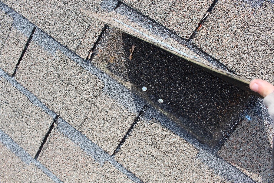
There are critical considerations with regards to UAS inspections and their present limitations. These considerations may be well-known to those with years of field experience and/or the benefit of taking a Haag Education class or certification course on roof damage assessment. For asphalt shingle roofing (the most common residential roof covering in the U.S.), UAS imagery will not indicate if shingles are unsealed, if unsealed shingles mimic installation patterns, if nails were placed too high or omitted (unless perhaps if revealed by photos of torn-off tabs), or if creased tabs which were not folded back failed by cohesive or adhesive modes. Further, it may be difficult to document some or all of the creased shingles if these were not folded back.
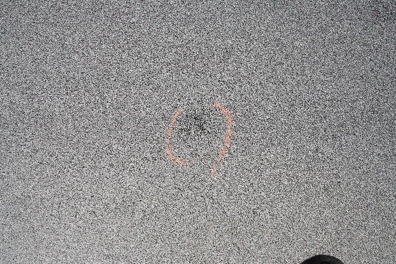
Figure 2. Creased shingle marked with chalk. Shingle lifted to reveal fastener type and placement.
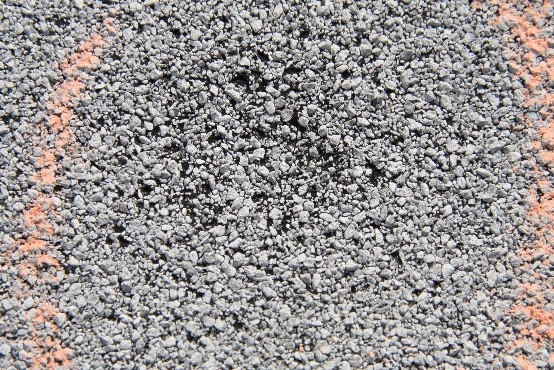
For asphalt roofing in general—including shingles, modified bitumen, built-up, and roll roofing—questions abound regarding the ability of UAS to detect hail damage. Several companies tout their ability to detect granule loss or “hail damage” via UAS inspection. While baseball-sized or larger hail impacting an asphalt shingle roof is likely to be readily discernible from such images just as it would be from the ground (depending on roofing visibility) or upon stepping on the roof, what about smaller hail? Algorithms may claim to be able to detect effects from hail of any size, but would such algorithms also include in this count non-hail-caused granule loss commonly resulting from handling and installation, natural weathering, foot traffic, lichens, protruding nails, blisters, and manufacturing anomalies, as well as marring from installation, maintenance, and tree branch scuffs? Such granule loss would greatly skew the amount of “hail damage” detected. Further, inspections limited to UAS data would not include tactile inspections to confirm if a shingle or other asphalt roofing was bruised (i.e., if the reinforcement mat was fractured) by hail impact. Consider two professionals standing on a roof who have differing opinions whether conditions below their feet resulted from hail or wind. Such arguments will not be resolved simply because a drone flew over a roof.
For tile roofing, concerns may arise if tiles were loosened or displaced by wind. Tactile inspection of tile attachments, including the amount by which tiles can be lifted across different areas of the roof, observations of relative timeframes of tile displacements, and other critical information may need to be gathered from the roof. For clay and concrete tile roofs, determining whether tiles were broken by foot traffic, debris impact, wind forces, over-driven fasteners, or other stresses is another issue that photographs alone are unlikely to resolve. For wood shakes and shingles, documenting if splits were caused by hail, foot traffic, or natural weathering could be an arduous task, at best, from purely UAS images. For single-ply membranes, one might need to determine if the membrane or underlying insulation have been lifted or loosened by wind, if the underlying insulation had been indented or fractured by hail, or if small fractures in the membrane had been caused by hail. Once again, roof-level, tactile inspection could be warranted.
Another consideration is roof leak evaluations. Interior and/or attic inspections could be required to determine leak locations, differentiate from HVAC and/or plumbing leaks, and determine approximate duration of leakage and extent of damage.
Many other such limitations and considerations abound. In the end, a UAS is another tool at the disposal of the adjuster, forensic engineer, and/or consultant. Combined with weather data and other site-specific information, a UAS inspection can provide useful data such as images and measurements (in addition to several other data sets depending upon the payload) and reduce risks of injury and property damage. UAS pilots should be licensed, insured, and trained to focus on pertinent aspects of roof inspections. Professional knowledge and judgment remain critical factors in any forensic evaluation. The capabilities and usage of UAS inspections are expected to increase as technology and industry acceptance continue to evolve.
About the authors:


